Solar X-rays:
![]()
Geomagnetic Field:
![]()
From n3kl.org


Was browsing hackaday today and saw a post about NOAA weather satelite images. I realized I never posted my own experinces here, so I thought I would go ahead and document it.
First off, it is important to remember that this all came about due to a number of different factors: My brother had actually bought two EZCap SDR tuners because he was interested in scanning police bands and some other stuff. He had mentioned he had them, and by then I was already aware that one could tune in the frequencies required for satelite reception.
People have been tuning in these NOAA weather satelites for years, boing back to when the first satelite was launched. It is not particularly hard. In the past however, you not only had to construct an appropriate antenna, but receiver as well. I must state that nothing we did here is new. We followed the work of others very closesly, and attempted to replicate the process. We were not the first to receive satelite imagry with cheap tv tuner dongles.
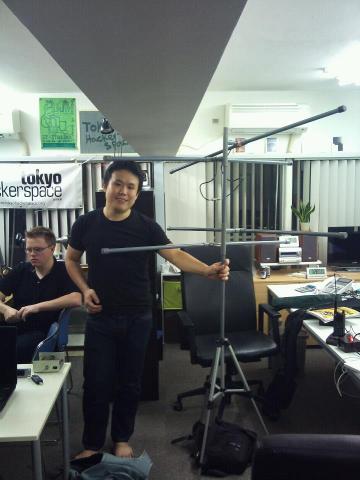 In fact, after returning to Japan, one of my Japanese friends at Tokyo Hackerspace heard my report of the trip, and mentioned that he himself did this very same thing while in university. The design of the the radio receiver and antenna was one of his thesis projects. That is Shingo standing with what he calls the "Kendo Antenna" so named because it all collapses and is easilly carried in his old kendo shinai case. It is made from small diameter PVC-U pipe fittings. Inside he just uses regular two conductor flat antenna wire. It is arranged as dipole loops, similar to a Lindenblad (?)
So, armed with some rudimentary knowledge, we went about collecting enough information to replicate the results. My brother had already been working with HDSDR for some time, and had the dongle working properly, as well as a good working knowledge of the software. I must admit, it took some time to get me up to speed on the software. He also found a copy of the ARRL handbook and procured materials for a helical antenna from the local hardware store.
When I arrived in Arizona, I got to work sorting out the work flow process and additional software required. I had a large collection of sites to read up on. See the appendics below for more.
We built a quadrifilar helix reception antenna, tuned approximately to 137.5 Mhz. I say "approximately", because we took some liberties in construction and material choices. To say it was an amature design is an understatement. It was constructed mostly of PVC pipe and copper wire.
The reception and decoding workflow process roughly goes like this:
Results
It took us several tries. At first, we thought we just did not have the right equipment. We had predictions, but found no satelites. Further investigation provided conflicting information. As it turns out, my laptop still thought it was in Tokyo! This will really fubar your prediction maps. Once that problem was fixed, and we had downloaded the latest Kepler files, we had confidence that the next pass would work.
Again we were dissapointed. I found that APTDecoder is MUCH better at mapping than WXtoImg, but it's pass prediction was hard to understand. So I used both in conjunction. WX gave me decent predictions, and then APTDec told me where that sat was at the moment. The ultimate solution came in the form of n2yo.com. Use that to predict and you wont have any issues. If you are offline, be sure to have both WX and APT, or find a newer, better solution.
Finally with good predictions, we started to get decent signal, but still no clean images. We still had not figured out live decoding, but had at the very least audibly confirmed we were locked on a satelite, by the tone. We compared this tone to videos on youtube and were certain we had a good signal.
After feeding the HDSDR file to WXtoImg we were totally MIFFED at the output. Nothing. Apparently. We had good side bars (we didnt know at the time that that was what we were looking at) with mostly static and black in the middle.
As it turns out, we had discovered that one satelite that still has a working radio, but bad camera. We were receiving the one dead satelite in orbit that still transmits! Once we confirmed this, we were positive we at least had a working system, and just needed to wait for the next pass.
By now, it was REALLY late, and the next pass was predicted for 4 am. I decided to stick with it and give it one final chance.
This time, we DID get a good signal. Other than a few moments of me fiddling on the receiver (which left blanks and static in both the live decode and the archive audio), the image was clear! Unfortunately, it was night, with HEAVY overcast. But we could clearly make out the storm patterns overhead.
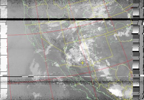
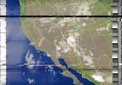
After infrared and false color filtering, the southwest United States appeard on the screen. I immediately went to the NOAA weather site and checked their images to compare our own, and could match up the cloud patterns exactly.
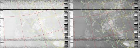
Above is the raw data, after straigtening.
I believe this is the raw infrared, with WXtoImg map overlay.
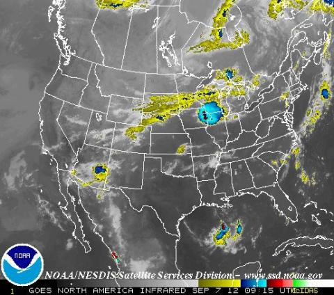
Above is the official NOAA imagry. Notice the cloud formation off the coast of california. This matches clearly to our own imagry.
Our image after false color. Note that due to heavy cloud cover, as well as the fact that this was imaged at night, the false color imagine looks rather dull, with few land features visible.
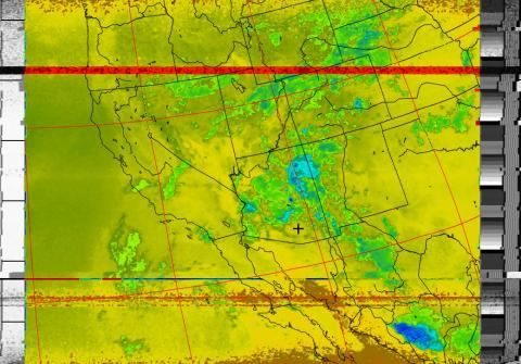
Here we have the infrared thermal image. Unfortunately, the software provides no scale.
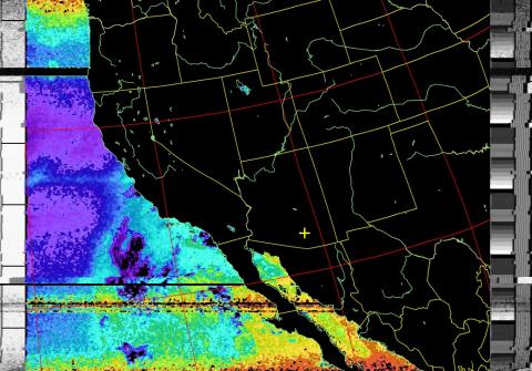
Here we have the ocean thermal. Again, no scale.
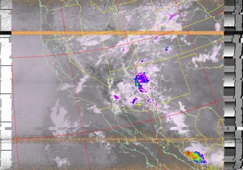
Finally, there is what is called NO enhancement (not no as in None. It is looks very similar to what you would expect to see on the weather channel. It is not a thunderstorm enhancement, but has much the same effect.)
Below you will find attached the .wav file of this satelite pass. Feel free to download it and try it yourself in WXtoImg or APTDecoder. Or just listen to get a feel for what you should be hearing on your own attempts. Down in the middle of the file, the static clears up, and the signal is clear and strong. The sat is directly overhead.
I will update this article with images of our antenna, once my brother passes them along to me.
Appendix
General Receiving Process:
Satelites and Tracking
Software
Theme by Danetsoft and Danang Probo Sayekti inspired by Maksimer